Adopted Maps
This page lists the Citizen Redistricting Committee’s final adopted district maps of each office being redistricted under the Redistricting Act and the Committee’s Rules of Procedure. See Laws 2021, Chapter 79, Sections 6-8; CRC Rule of Procedure 11(A). The Citizen Redistricting Committee will transmit these maps to the legislature on October 30, 2021 or as soon as practicable thereafter.
This page also provides block equivalency files for all adopted maps. A block equivalency file lists each Census block and its district assignment, and can be easily imported into other redistricting software to recreate the plan. To download the block equivalency files for all adopted maps, please click here.
If you have questions about the maps or other information on this page, please contact Committee staff at crc@state.nm.us.
CONGRESSIONAL DISTRICTS MAP CONCEPTS
Congressional Concept A:
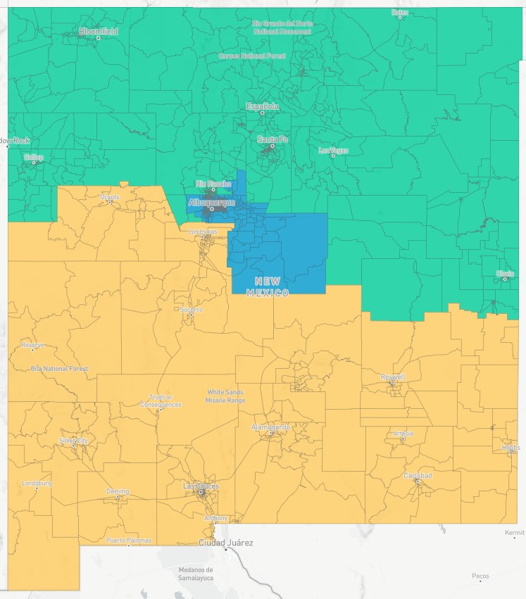
Congressional Concept A:
Click here to view table summary (demographics)
Votes:
| Ryan Cangiolosi | Y |
| Lisa Curtis | N |
| Robert Rhatigan | Y |
| Joaquín Sanchez | N |
| Michael Sanchez | N |
| Christopher Saucedo | Y |
| Edward Chávez | Y |
To view the full-detail map, click the Distictr link below:
https://districtr.org/plan/43318?portal&draft=d1
Objective:
- Maintain status quo. Keep Torrance County with Bernalillo County, Placitas, and Bernalillo in CD 1
- Cibola County in CD 2
- Isleta in CD 2
Congressional Concept E-Revised (Justice Chávez’s map):
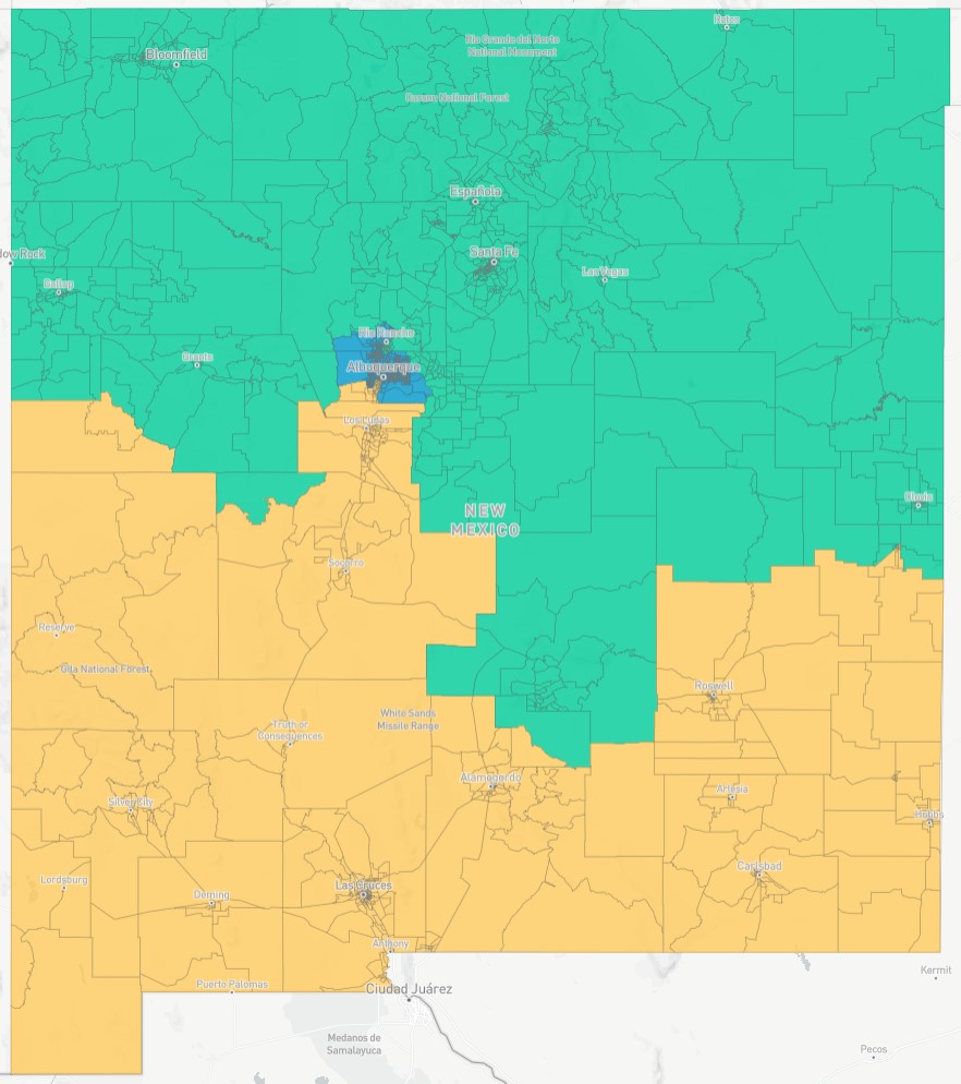
Congressional Concept E-Revised (Justice Chávez’s Map)
Click here to view table summary (demographics)
Votes:
| Ryan Cangiolosi | Y |
| Lisa Curtis | Y |
| Robert Rhatigan | Y |
| Joaquín Sanchez | N |
| Michael Sanchez | Y |
| Christopher Saucedo | Y |
| Edward Chávez | Y |
To view the full-detail map, click the Distictr link below:
https://districtr.org/plan/63307?portal
Objective:
- This plan is similar to CRC Congressional Concept E modified except it is with the new precincts. Population deviation is 0.01%
- This map also splits the Navajo Nation to equalize population consistent with Pueblo and Apache map feedback.
Congressional Concept H: (CCP – Peoples Map / El mapa de la gente)
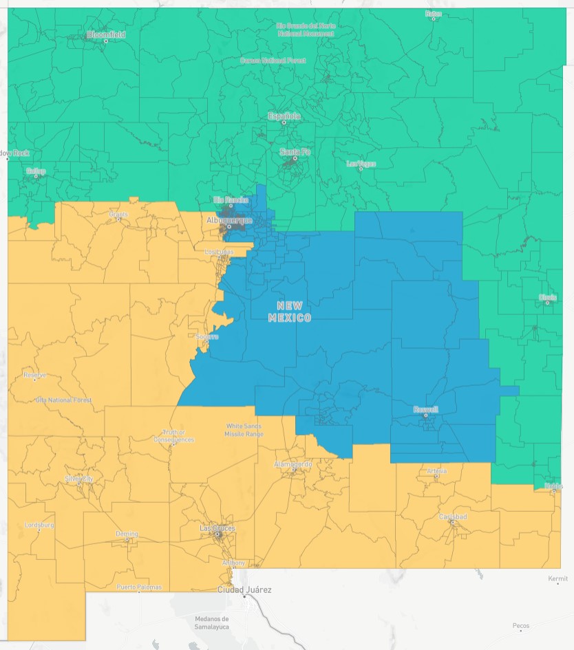
Congressional Concept H (designed by the Center for Civic Policy on behalf of the People’s Power, People’s Maps Coalition):
Click here to view table summary (demographics)
Votes:
| Ryan Cangiolosi | N |
| Lisa Curtis | Y |
| Robert Rhatigan | Y |
| Joaquín Sanchez | Y |
| Michael Sanchez | Y |
| Christopher Saucedo | N |
| Edward Chávez | Y |
To view the full-detail map, click the Distictr link below:
*Note that the original map was drawn with the incorrect district numbering. The link below redirects to the redrawn map with correctly numbered districts and updated precincts.*
https://districtr.org/plan/66395
Objective:
-
This map combines feedback from a coalition of community-based organizations throughout the state.
-
The stated goal of the Coalition is fair representation for their communities.
- To read the full description, please view this map’s post on the public comment portal here: https://portal.newmexico-mapping.org/submission/p5025
SENATE DISTRICT MAP CONCEPTS
Senate Concept A-1:
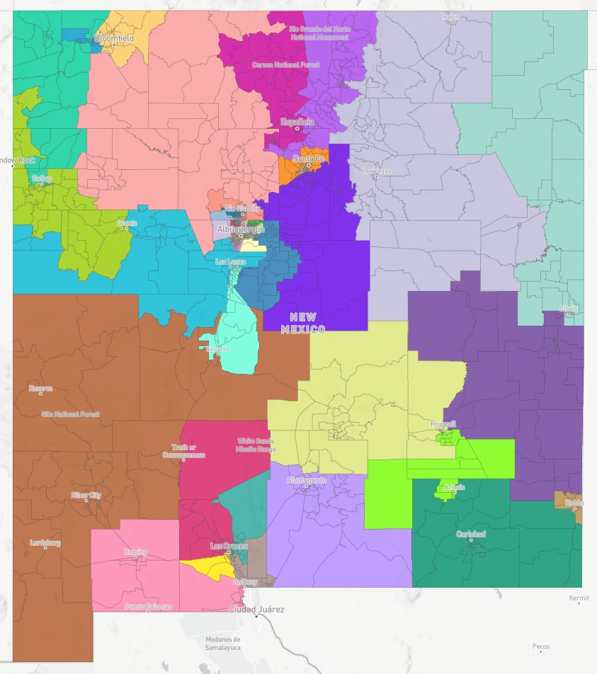
Senate Concept A-1:
Click here to view table summary (demographics)
To view the full-detail map, click the Distictr link below:
https://districtr.org/plan/64078
Votes:
| Ryan Cangiolosi | N |
| Lisa Curtis | Y |
| Robert Rhatigan | Y |
| Joaquín Sanchez | Y |
| Michael Sanchez | Y |
| Christopher Saucedo | Y |
| Edward Chávez | Y |
Objective:
- This map is based on Senate Concept A, but is revised to reflect new precinct data.
- Does not split Hobbs, Carlsbad, Artesia, Ruidoso, Lovington, and Alamogordo, and still maintains two majority Hispanic districts in SE NM.
- Maintains three stronger Native American majority voting age districts, by utilizing Laguna/Acoma and Zuni Pueblos as part of the majority Native American districts. One of the districts is predominantly Pueblo/Jicarilla and two districts are predominately Navajo. SD 30 is used to bolster Native American districts instead of creating a Native American “influence” district.
- SD 39, that currently sprawls from Mora County to Rio Communities in Valencia County, and down to Ruidoso, is compacted into an Eldorado, Pecos, Placitas district, with a common bond of adjacency to mountains and wilderness areas and concerns for the environment.
- White Rock is with northern Santa Fe County and Taos. Los Alamos is with the Rio Arriba district. (This is status quo.)
- Pursuant to public feedback:
- Edgewood is not split, and it is included in an East Mountain district.
- Chaparral is not split and is included in a district with Anthony rather than Carlsbad and Alamogordo.
- More Hispanic neighborhoods (communities of interest) are included in the Roswell and Hobbs minority districts.
- In Albuquerque, north of I-40, the Rio Grande is used as a hard boundary separating the North Valley from the Westside.
- The International District is wholly contained in one Senate district.
- District boundaries in urban areas are straightened and priorities are given to major thoroughfares.
Senate Concept C:
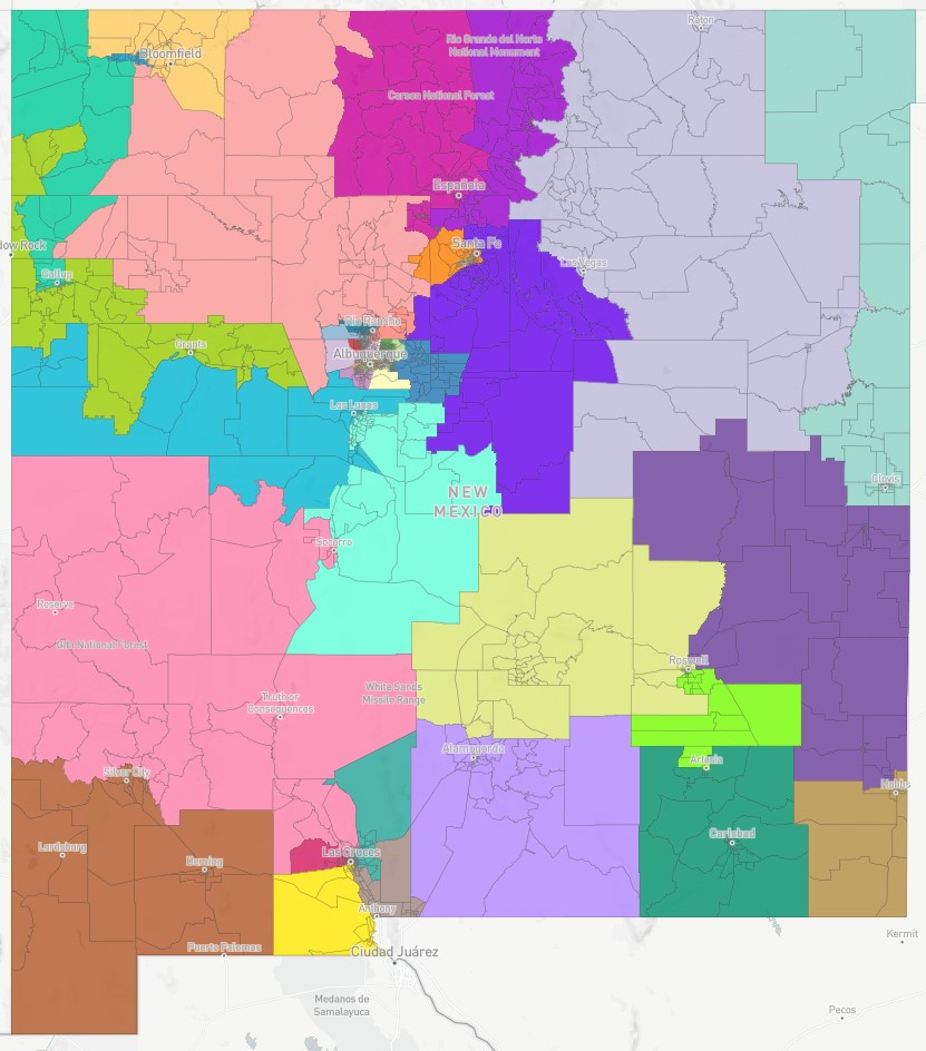
Senate Concept C:
Click here to view table summary (demographics)
Votes:
| Ryan Cangiolosi | Y |
| Lisa Curtis | N |
| Robert Rhatigan | Y |
| Joaquín Sanchez | N |
| Michael Sanchez | N |
| Christopher Saucedo | Y |
| Edward Chávez | Y |
To view the full-detail map, click the Distictr link below:
https://districtr.org/plan/45412
Objective:
- Chaparral/Anthony district does not include Sunland Park, and Chaparral is not split. Sunland Park district goes into Las Cruces.
- Los Alamos County split (status quo) with Los Alamos with Rio Arriba (SD 5) and White Rock with Northern Santa Fe County in Taos District (SD 6).
- This Los Alamos split allows SD 7 and SD 8 (NE NM) to maintain a more status quo orientation, as compared to Concept B.
- Eddy County has a district that stays within the county’s boundaries.
- Maintains two majority Hispanic districts: Hobbs-based (55.4%) and Roswell-based (60.7%). Artesia and Hobbs are split. Carlsbad is whole.
- Two Westside Albuquerque districts take on a north/south configuration.
Senate Concept C-1:
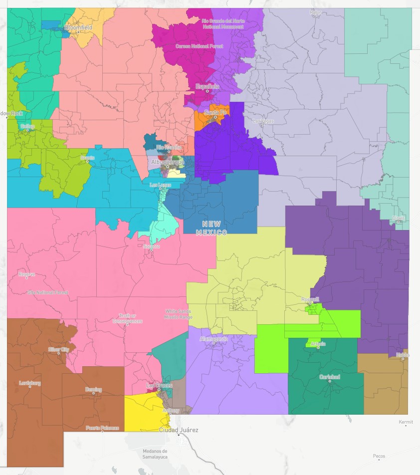
Senate Concept C-1:
Click here to view table summary (demographics)
Votes:
| Ryan Cangiolosi | N |
| Lisa Curtis | Y |
| Robert Rhatigan | Y |
| Joaquín Sanchez | Y |
| Michael Sanchez | Y |
| Christopher Saucedo | N |
| Edward Chávez | Y |
To view the full-detail map, click the Distictr link below:
https://districtr.org/plan/67358
Objective:
- This map is based on Senate map concept C.
- Chaparral/Anthony district does not include Sunland Park, and Chaparral is not split. Sunland Park district goes into Las Cruces.
- Los Alamos County split (status quo) with Los Alamos with Rio Arriba (SD 5) and White Rock with Northern Santa Fe County in Taos District (SD 6).
- This Los Alamos split allows SD 7 and SD 8 (NE NM) to maintain a more status quo orientation, as compared to Concept B.
- Eddy County has a district that stays within the county’s boundaries.
- Maintains two majority Hispanic districts: Hobbs-based (55.4%) and Roswell-based (60.7%). Artesia and Hobbs are split. Carlsbad is whole.
- Two Westside Albuquerque districts take on a north/south configuration.
House District Map Concepts
House Concept E-1 (Acequias Modification of Concept E, ID: p5656 in Districtr)
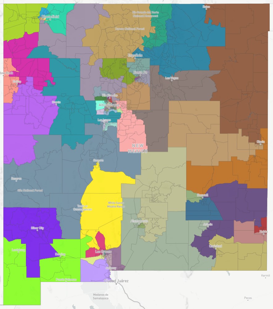
House Concept E-1 (Acequias Modification of Concept E, ID: p5656 in Districtr)
*Note that the current Districtr map does not reflect the updated precincts. Therefore, the data in Districtr is not the official data as listed in the summary table linked below. When the precincts are updated in Districtr, the map will be updated.
Click here to view table summary (demographics)
Votes:
| Ryan Cangiolosi | N |
| Lisa Curtis | Y |
| Robert Rhatigan | Y |
| Joaquín Sanchez | Y |
| Michael Sanchez | Y |
| Christopher Saucedo | N |
| Edward Chávez | Y |
To view the full-detail map, click the Distictr link below:
https://districtr.org/plan/64371
Objective:
- This map is based on version of house map concept E, that was modified by the NM Acequia Association.
- House District 70 is adjusted by keeping the east side of San Miguel County in District 70 (including the area of Las Vegas east of Grand Avenue).
- Returns some precincts in the Raton area to the northeastern/eastern House district.
- To offset that loss of population, this map picks up one precinct in Taos and puts three San Miguel precincts (which are currently in District 40) back into the district: Montezuma, Sapello, and Rociada.
- By restoring some precincts that are currently in District 40 and District 70, this map better retains the status quo while adjusting the districts to account for population loss in the area. This is accomplished with modest adjustments to precincts in neighboring districts on the west side of the district (Rio Arriba, Taos) and southern boundary (San Miguel).
- Chair, Justice Edward Chávez re-worked this map to include feedback from the New Mexico Acequia Association.
-
They expressed the concern that Concept E changes the character of district 40 by adding a substantial population center from the northeastern plains to District 40. Doing so dilutes the influence of acequia/rural/mountain communities in District 40. The modification also avoids splitting the City of Las Vegas at Grand Avenue and putting the east side of Grand Avenue into the district dominated by Clovis. The modification keeps a substantial part of a small town population in Las Vegas, thereby avoiding the weakening of District 70.
House Concept I-1 (Concept D integrating Pueblo Consensus NW region with CRC member request)
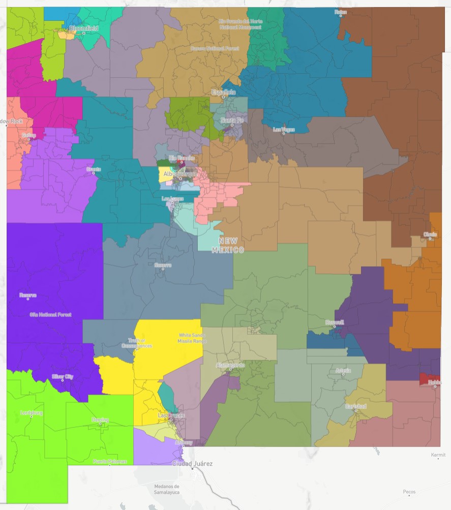
House Concept I-1 (Concept D integrating Pueblo Consensus NW region with CRC member request)
Click here to view table summary (demographics)
Votes:
| Ryan Cangiolosi | N |
| Lisa Curtis | Y |
| Robert Rhatigan | Y |
| Joaquín Sanchez | Y |
| Michael Sanchez | Y |
| Christopher Saucedo | N |
| Edward Chávez | Y |
To view the full-detail map, click the Distictr link below:
https://districtr.org/plan/67300
Objective:
- Based on concept I, with the added goals of integrating the Pueblo consensus map and CRC member request to unpair HD 21 and 24.
- Status quo oriented plan with fixes to account for population shifts in the current map and other improvements.
- Creates 5 strong Native American districts (63.7% or higher) and one Native American influence district centered around the 7 Sandoval County Pueblos.
- HD 40 and HD 70 are maintained with HD 40 continuing to cross over the Sangre de Christos into Rio Arriba County.
- Westside Albuquerque districts move northward to absorb the excess population.
- Maintains the Rio Grande as a hard boundary north of I-40.
- Keeps Edgewood together.
- Silver City unified into one district.
- Chaparral is not split and is included in a district with Anthony.
- More Hispanic neighborhoods (communities of interest) are included in the Roswell and Hobbs minority districts.
House Concept J (Integrating Navajo Nation NW Quadrant Districts)
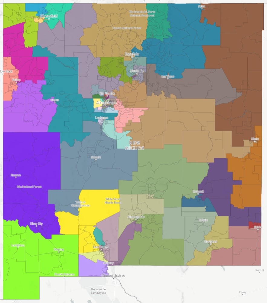
House Concept J (Integrating Navajo Nation NW Quadrant Districts)
Click here to view table summary (demographics)
Votes:
| Ryan Cangiolosi | N |
| Lisa Curtis | Y |
| Robert Rhatigan | Y |
| Joaquín Sanchez | N |
| Michael Sanchez | Y |
| Christopher Saucedo | N |
| Edward Chávez | Y |
To view the full-detail map, click the Distictr link below:
https://districtr.org/plan/64356
Objective:
- Based on Concept D with the added goal of integrating the Navajo Nation’s proposed districts in the NW quadrant.
- Status quo oriented plan with fixes to account for population shifts in the current map and other improvements.
- Creates 5 strong Native American districts (63.7% or higher) and one Native American influence district centered around the 7 Sandoval County Pueblos.
- HD 40 and HD 70 are maintained with HD 40 continuing to cross over the Sangre de Christos into Rio Arriba County.
- Westside Albuquerque districts move northward to absorb the excess population.
- Maintains the Rio Grande as a hard boundary north of I-40.
- Keeps Edgewood together.
- Silver City unified into one district.
- Chaparral is not split and is included in a district with Anthony.
- More Hispanic neighborhoods (communities of interest) are included in the Roswell and Hobbs minority districts.
Public Education Commission District Map Concepts
PEC Concept A:
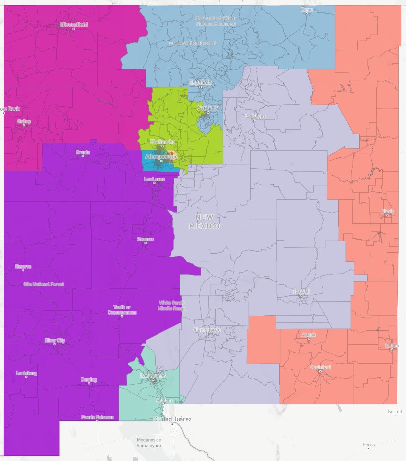
PEC Concept A:
Click here to view table summary (demographics)
Votes:
| Ryan Cangiolosi | Y |
| Lisa Curtis | Y |
| Robert Rhatigan | Y |
| Joaquín Sanchez | Y |
| Michael Sanchez | Y |
| Christopher Saucedo | Y |
| Edward Chávez | Y |
To view the full-detail map, click the Distictr link below:
https://districtr.org/plan/45565
Objective:
- Status quo plan that maintains the core of existing PEC districts and adjusts the district boundaries to account for population shifts.
PEC Concept C:
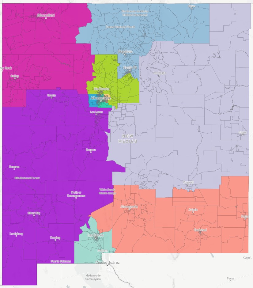
PEC Concept C:
Click here to view table summary (demographics)
Votes:
| Ryan Cangiolosi | Y |
| Lisa Curtis | Y |
| Robert Rhatigan | Y |
| Joaquín Sanchez | Abstain |
| Michael Sanchez | Y |
| Christopher Saucedo | Y |
| Edward Chávez | Y |
To view the full-detail map, click the Distictr link below:
https://districtr.org/plan/45578
Objective:
- Keeps Westside of Albuquerque wholly contained in one district. The South Valley (east of Coors Blvd.) is included with the North Valley and the International District.
- South of I-25 in Santa Fe County (including Eldorado) is included in a Los Alamos/East Mountains/Sandoval County district instead of a North Central NM district.
PEC Concept E (Leonard Gorman – NNHRC):
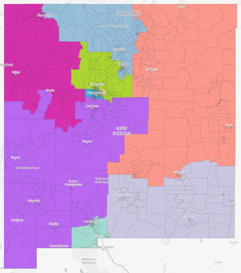
PEC Concept E (Leonard Gorman – NNHRC) Submitted 10/12/2021:
Click here to view table summary (demographics)
Votes:
| Ryan Cangiolosi | Y |
| Lisa Curtis | Y |
| Robert Rhatigan | Y |
| Joaquín Sanchez | Y |
| Michael Sanchez | Y |
| Christopher Saucedo | Y |
| Edward Chávez | Y |
To view the full-detail map, click the link below.
https://districtr.org/plan/64470
